
The course starts in Pak Tam Chung on the east side of Hong Kong’s New Territories and winds its way west along coastal paths, across beaches, through ancient villages, over hills and through valleys before finishing with a descent from Tai Mo Shan, Hong Kong’s highest peak.
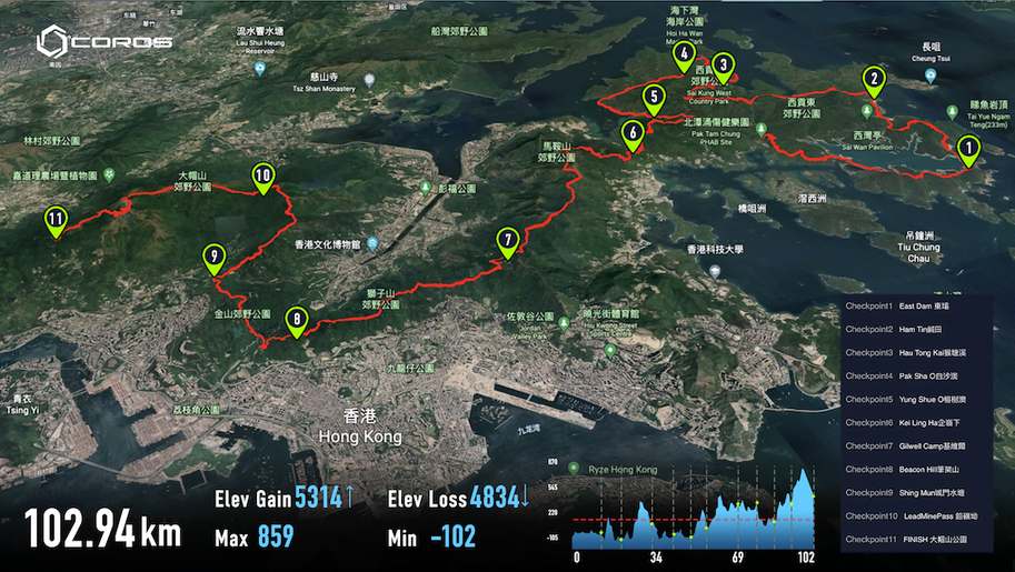
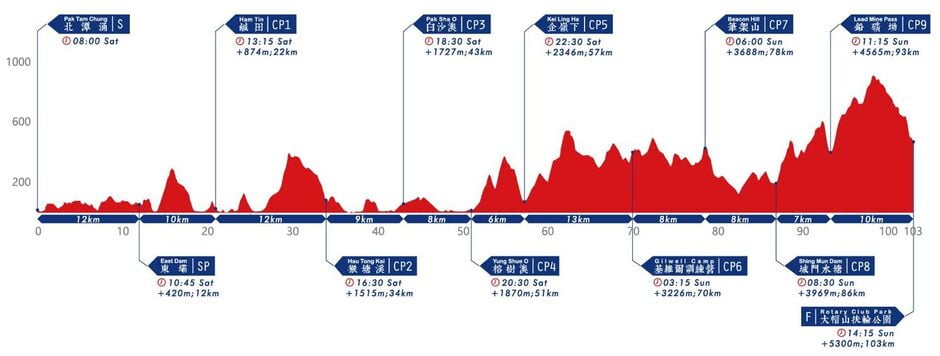
The Hong Kong 100 course starts in Pak Tam Chung on the east side of Hong Kong’s New Territories and winds its way west along coastal paths, across beaches, through ancient villages, over hills and through valleys before finishing after the descent of Tai Mo Shan, Hong Kong’s highest peak (at 957m). The 103km journey climbs over 5,300m and much of the climbing is in the second half of the course, so it’s important that runners pace themselves sensibly over the first half, leaving something in reserve for the hillier sections later on.
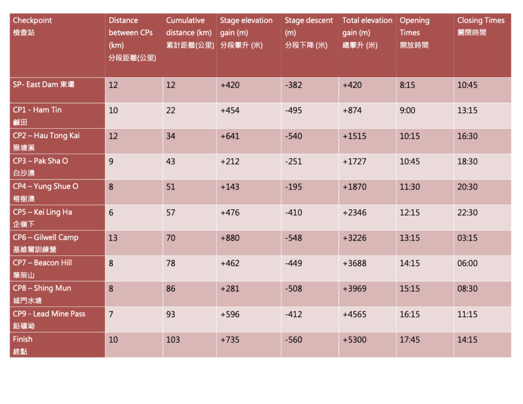
The first half of the course winds around the coast of the Sai Kung peninsula. The first 800 metres are on a sealed road before a sharp right turn leads to the Sheung Yiu Country Trail, which features 5km of classic Hong Kong winding country trail with views out to the islands in the South China sea. A further 5km on sealed road over dams built to form reservoirs leads to the first support point at East Dam (12km). Don’t forget to take in the views of the Hong Kong UNESCO Global Geopark as you refuel!
From the support point to the first checkpoint requires a climb over Sai Wan Shan (314m) and crossing Sai Wan and Ham Tin beaches. Enjoy the waves crashing into the pristine white sand and ignore the temptation to join the surfers.
From CP1 (Ham Tin – 21km) to CP2 (Hau Tong Kai BBQ site – 34km) the course undulates along Stage 2 of the Maclehose Trail to Pak Tam Au (cross the road carefully!). From Pak Tam Au you climb steeply up Ngau Yee Shek Shan which rises to almost 400m above sea level. This is a more beautiful climb than its name (“Cow’s Ear Rock Hill”) suggests and the views to the islands (including golfers’ paradise, Kau Sai Chau) to your left as you summit are some of the prettiest on the whole course. After the descent you turn sharply right at Cheung Sheung to fly down the Cheung Sheung Country Trail, a soft and bouncy trail runner’s dream. Turn left when you reach Hoi Ha Road and CP2 is about 300m up the road on your left.
Suitably refreshed, to reach CP3 (Pak Sha O – 43km) turn right out of CP2, cross the road (carefully!) and re-trace your steps back down Hoi Ha Road. After about 200m, turn left onto a trail which heads down to Tai Tan village. When you reach the village, turn left on the trail to Hoi Ha. Although this trail looks flat from the course profile, it is a wee bit technical, featuring rocky and rooty trails, with some wonderful sea-views to your right- hand side. Hoi Ha, at around 41km, is a marine sanctuary, where if you swapped your running shoes for a mask and snorkel you could see soft coral, anemones, clown-fish and garoupa. CP3 (Pak Sha O – 43km) is inside the youth hostel just beyond the Pak Sha O turning on Hoi Ha Road.
From CP3 to CP4 (Yung Shue O – 51km) is a mixture of fast coastal path and dirt trail. Watch out for the magnificent views across Kei Ling Ha towards Ma On Shan (“Saddle Hill”) as you approach the CP.
As you leave CP4 the real climbing starts. Kai Kung Shan (“Rooster Hill”) (399m) stands between you and your drop bag at CP5 (Kei Ling Ha – 57km).
CP5 to CP6 (Gilwell Camp – 70km) is the race’s longest and hardest stage (make sure you have enough liquids), but includes some of its most beautiful scenery. The ridge line after Ma On Shan provides incredible views over Sai Kung and the hundreds of islands in the South China Sea, and the chance to open up on smooth, runnable orange-colored dirt trail. A warm welcome awaits at Gilwell Scout Camp.
If you can drag yourself away from the campfire and the marshmallows, the route from Gilwell Camp to CP7 (Beacon Hill – 78km) provides the best city views of the whole course as you traverse behind Lion Rock looking out over Kowloon to the shimmering glass towers and neon lights of Hong Kong island. Feast your eyes on the world’s most beautiful cityscape, before climbing up to Beacon Hill where the party will be in full swing.
From CP7 to CP8 (Shing Mun – 86km) requires a sharp descent into monkeyland, then for 5km you’ll be sharing the trails, the bridge across Tai Po Road (which every runner must use for both safety and fairness) and the climb up the sealed road of Golden Hill with the cheeky, thieving, mischievous macaques. If you eat here, they will snatch your snack!
As you leave Shing Mun you have just 3 climbs to go. First up, the strength-sapping but majestic Needle Hill (532m). It’s very steep, but with a steady plod you’re over the top before you know it. And don’t forget to enjoy the views to your right of Sha Tin – the world’s finest horse-racing stadium – and to the left of Tai Mo Shan – Hong Kong’s highest peak and the culmination of your journey. After Needle Hill comes Grassy Hill (647m), a winding sealed road (runnable for the toughest competitors, plodable for mere mortals) and the sharp descent to CP9 (Lead Mine Pass – 93km). Don’t even think about dropping out here – you have just 10km to go and the CP is inaccessible to vehicles, so it’s easier to shuffle to the finish than to walk out of the country park!
One last push and you’re over Tai Mo Shan (957m) and have a 4km run mostly downhill (with, since the hugely popular 2016 route change, some trail, some steps and one uphill bump) to the party and the glory at the finish line. What could be simpler?
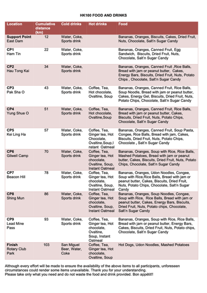
The course is rocky, uneven and steep in places. Take great care at all times and never overtake unless it is safe to do so. Give way to participants who are moving more quickly than you. Encourage one another and look out for each other’s safety and well-being. Ensure that you will have enough to eat and drink to reach the next check-point. Be particularly careful to drink enough and carry enough fluid. It is vital for your safety that you maintain adequate levels of hydration.
For further information on safety, please see the safety hints on the AFCD’s website at: http://www.afcd.gov.hk
Emergency first aid will be available at each checkpoint.