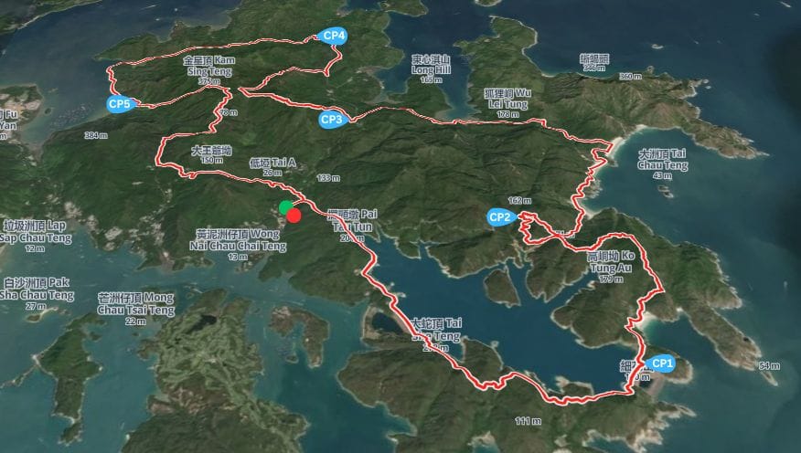
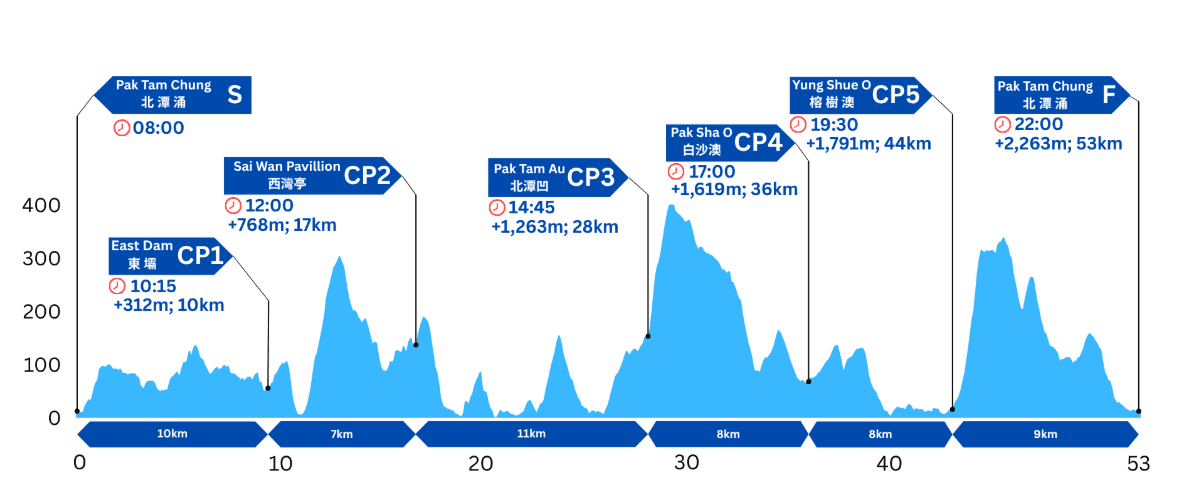
The Half course starts in Pak Tam Chung on the east side of Hong Kong’s New Territories and winds its way around the coast of the Sai Kung peninsula along coastal paths, across beaches, through ancient villages, over hills and through valleys before returning to Pak Tam Chung. The 53km journey climbs over 2200m and offers amazing views of this beautiful corner of the planet.
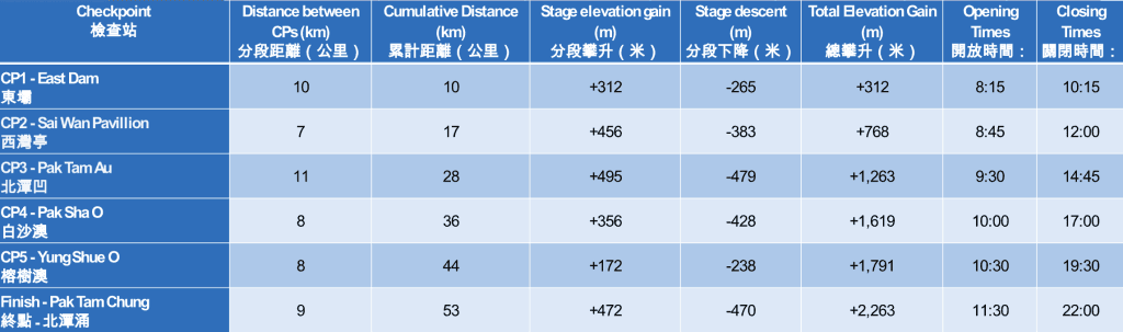
The first 10km follows the Maclehose Trail with views out to the islands in the South China sea on the right and across High Island Reservoir on the left. The route travels over dams built to form the reservoir leading to CP1 at East Dam (10km). Don’t forget to take in the views of the Hong Kong UNESCO Global Geopark as you refuel!
From East Dam to the second checkpoint requires a climb over Sai Wan Shan (314m). In a change for 2027 CP2 has been relocated to Sai Wan Pavilion before reaching the beaches.
From CP2 (Sai Wan Pavilion – 17km), it’s a short climb up to stunning views over the Sai Kung Country Park before descending to Sai Wan village and crossing Sai Wan and Ham Tin Beaches. The path skirts around the back of Ham Tin village and around to Tai Long Wan beach. About halfway along Tai Long Wan beach, wave the surfers goodbye and turn inland. After 1km of “jungle trail” rejoin the Maclehose Trail and the course undulates along Stage 2 of the Maclehose Trail to the relocated CP3 at Pak Tam Au (28km).
From Pak Tam Au you climb steeply up Ngau Yee Shek Shan which rises to almost 400m above sea level. This is a more beautiful climb than its name (“Cow’s Ear Rock Hill”) suggests and the views to the islands (including golfers’ paradise, Kau Sai Chau) to your left as you summit are some of the prettiest on the whole course. After the descent you turn sharply right at Cheung Sheung to fly down the Cheung Sheung Country Trail, a soft and bouncy trail runner’s dream. Turn left when you reach Hoi Ha Road and follow the road to Pak Sha O village and CP4 (36km). Runners must use the pavement and cross the road with care.
From Pak Sha O to CP5 (Yung Shue O – 44km) it is a mixture of fast coastal path and dirt trail. Watch out for the magnificent views across Kei Ling Ha towards Ma On Shan (“Saddle Hill”) as you approach the CP.
As you leave CP5 a couple of climbs await. The route leaves via the back of Yung Shue O village up the Cheung Sheung Country Trail to the Maclehose Trail Stage onto which you turn sharp right. Follow the Maclehose trail for 3km before turning left onto a trail heading past Ping Tun village. It’s then charge (mostly) downhill for 3km to the party and the glory at the finish line. Free beer for everyone! Welcome back!
The course is rocky, uneven and steep in places. Take great care at all times and never overtake unless it is safe to do so. Give way to participants who are moving more quickly than you. Encourage one another and look out for each other’s safety and well-being. Ensure that you will have enough to eat and drink to reach the next check-point. Be particularly careful to drink enough and carry enough fluid. It is vital for your safety that you maintain adequate levels of hydration.
For further information on safety, please see the safety hints on the AFCD’s website at: http://www.afcd.gov.hk
Emergency first aid will be available at each checkpoint.
Scan the QR code below in WeChat app